
The conversion of the Kellar Branch rail corridor to a recreational trail provides the missing link in a trail system that stretches from Toulon to Bloomington-Normal—and beyond.
It is a beautiful summer morning…a perfect day to spend outdoors along the Rock Island Trail. You can walk the trail, you can hike the trail and you can run the trail…but today, I am going to bike the trail.
Riding the trail is an adventure—a very doable adventure—and one in which you can set your own pace. You can travel with the kids to the store or meet a friend for lunch at one of the many eateries near the trail. Pack a picnic basket and stop along Grandview Drive, with its magnificent view of the Illinois River, or take the kids to the Peoria Zoo to see the giraffes, monkeys and lions. You can take a mini-vacation along the trail, traveling to neighboring towns and enjoying the sights along the way.
There are numerous trailheads at which you can start and end your trip. Already in existence are the trailheads at Pioneer Parkway, RiverPlex Wellness & Fitness Center, Fon du Lac Park District headquarters in East Peoria, and the Jackson/Jefferson intersection in Morton. Coming soon are trailheads at the Peoria Park District’s Bicycle Safety Town near Sheridan and Knoxville, and at the intersection of Marietta and Columbus avenues in Peoria Heights.
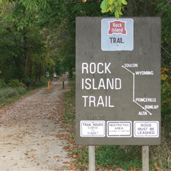
Officially dedicated in 1990, the Rock Island Trail was the first rails-to-trails park in Illinois, running 27 miles along the old Rock Island rail line from Toulon to Peoria. When the Kellar extension is completed, the Rock Island will connect to the Pimiteoui Trail to its south, and from there, one can follow the River Trail of Illinois through East Peoria to Morton, taking the Mackinaw Valley Trail all the way to Bloomington-Normal, where it will connect with the Route 66 Trail.
To its north, the Rock Island Trail will soon connect with the Hennepin Canal Trail, which is part of the Grand Trail of Illinois, a 500-mile network of trails and designated road routes stretching in a loop from Lake Michigan to the Mississippi River and back again. When it’s all said and done, the Rock Island will be an integral component in a network of recreational trails more than 1,000 miles long.
 A Summer Day’s Ride
I begin my morning at the northernmost end of the Rock Island Trail, in Toulon, the county seat of Stark County. Soon after leaving this small town, where Lincoln and Douglas spoke in 1858, I pass over the Spoon River on a most picturesque bridge, heading south to the old train depot in Wyoming. The depot was operated by the Chicago, Burlington & Quincy Railroad until 1954. Today, it houses a visitors’ center and museum that is open to the public and set as it was years ago, when hundreds of passengers traveled along the railway.
Leaving the old depot, I pass through a cool archway of trees, and soon, I am rolling across wooden bridges that cross the small creeks in the area. I arrive in the village of Princeville, named after Daniel Prince, who settled the area in the 1820s. Before the railroad was completed in 1871, Princeville was a stopping place for a stagecoach route that ran north and west out of Peoria. Today, if I wait for just a short while, I’ll catch the sight of a very fast train along the Santa Fe line, carrying its freight from one coast to the other.
Traveling on, I pass by large fields of corn and soybeans before entering the Village of Dunlap. On the south edge of town, there is a nice public park with a pavilion, where I can make a short rest stop. Nearby, the Prospect United Methodist Church sits on property that was the homestead of Alva and Mary Dunlap, who founded the village. In the 1840s, Alva Dunlap surveyed and mapped several roads in Radnor Township, including Mt. Hawley Road (now Route 40). A strong supporter of the railroad system, Dunlap gave the right of way through his property to the Peoria and Rock Island Railroad in 1871 and encouraged his fellow property owners to do the same. He laid out the Village of Dunlap that same year.
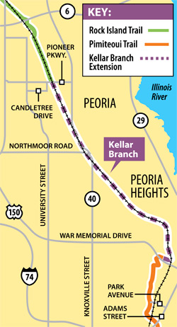
» The Kellar Branch: The Missing Link
The acquisition and conversion of this six-mile segment of the Kellar Branch was a milestone event, for it is the key missing link in the planned 1,100-mile network of recreational trails in Illinois.
The Kellar Branch rail line has a long history, having been first acquired by the Peoria and Rock Island Railroad shortly after the Civil War. After years of sporadic use, the line was abandoned, and in 1988, it was acquired by the City of Peoria and Village of Peoria Heights. The line was used for a time by the Peoria and Pekin Railway Company, which later assigned its lease to Pioneer Industrial Railway Company.
A six-mile segment of the line has long been planned for conversion to a public recreational trail that would link the Rock Island Trail, which now ends in Pioneer Park, to the Pimiteoui Trail, which begins in Springdale Cemetery and runs through Glen Oak Park to the Peoria riverfront. But various obstacles persisted over the years, raising doubts that this segment of the trail would ever be completed.
In 2007, the not-for-profit Kellar Branch Corridor Corporation was formed to facilitate the acquisition of the line for conversion to a recreational trail. The KBCC began a process to negotiate the acquisition of the railroad’s operating rights on this segment of the Kellar Branch. These efforts were successful, and with the cooperation of the Peoria Park District, Village of Peoria Heights and City of Peoria, the acquisition was consummated on May 20, 2010.
The conversion of the Kellar Branch to a recreational trail is not yet complete. The stretch from Candletree Drive to Northmoor Road is under construction and expected to be complete later this summer. Current plans call for a tunnel to be constructed beneath Knoxville near Junction City; until then, the traffic light at Northmoor will be used for the crossing. The 1.6-mile section from Knoxville to the Peoria Heights Library at Glen Avenue is complete, while the stretch from Glen to Springdale Cemetery is entering the final design stage, with construction planned for 2012.
Soon, I come to an area that is heavily wooded on both sides of the trail, and a newly developed parcel of large brick homes set in the woods between Dunlap and Alta. I stop on the bridge crossing over Kickapoo Creek to look for fish in the stream, and then climb a slight hill, passing beneath a girder bridge that carries the Union Pacific over the trail. Immediately after that is the only campground along the Rock Island Trail.
A Class D (primitive) campsite costs just $6 a night at the Kickapoo Creek Recreation Area, where 14 acres of land donated by Hazel Rutherford have been restored to native prairie. The campground has pit toilets, fire pads, picnic tables, picnic shelter and water, and a self-pay camping station is located off Fox Road at an overnight parking lot. Just a short distance away is the trailhead with pit toilets and a parking lot on Grange Hall Road, near Allen Road.
The trail rolls through a scenic wooded area, and I am now on Peoria Park District asphalt. I walk my bike through a tunnel beneath Route 6 before winding through tall grasses and trees past the Mt. Hawley Airport, visible on my left. I approach Pioneer Parkway, a very busy road, and stop at the traffic light to cross for safety.
Once across the street, I travel about two blocks, turn left onto Candletree Drive and head back to the trail, with residential homes along both sides. In about two miles, I approach the Peoria Park District’s Bicycle Safety Town, which will become a major trailhead. At this facility, youngsters can learn about bicycle safety by riding on simulated roads with real road signs, working traffic signals, ramps, overpasses and a bridge. In nice weather, you will notice parents there with their little ones, learning the rules of the road and having fun.
Pedaling on for a short distance, I come to Junction City, a railroad-themed center with numerous eateries and other unique shops. On this beautiful, sunny day, I stop at Cyd’s Gourmet Kitchen for a delicious lunch outdoors.
The next point of interest along the trail is the Peoria Heights Public Library, a good place to leave your car if you choose to start your trek from here. Just a short distance on is the downtown area of Peoria Heights, with its full array of shops and great restaurants, as well as Tower Park, the setting for many concerts and special events that take place throughout the year. The tower has an elevator that will take you to the highest point in the Tri-County Area, where you can see for miles on a clear day.
Just across the street is Grandview Drive, with its breathtaking view of the Illinois River Valley—especially in the fall, when the leaves change colors. Teddy Roosevelt called it “The World’s Most Beautiful Drive” when he visited Peoria in 1900.
As I leave the Heights, I pass near the planned trailhead at Marietta and North Columbus, and soon, I can see the golf course of the Country Club of Peoria on my left. Approaching War Memorial Drive, I take a right turn, pass under the road and enter Springdale Cemetery. Springdale is a beautiful and historic part of the Peoria area, with many famous names from the past on mausoleums and other markers. Coming out of the cemetery, I travel the asphalt trail running along the edge of Glen Oak Park, with Perry Avenue on my left.
Turning left onto Abington, I travel four blocks on a shared street with bicycle lane markings. As I approach the Illinois River, I turn onto the Pimiteoui Trail after crossing Adams Street. Winding parallel with the river for about a mile, I get a nice view of the waterway and arrive at the RiverPlex Recreation & Wellness Center, a beautiful complex with membership open to the public.
Leaving the RiverPlex, I travel under the Murray Baker Bridge, which carries Interstate 74 into and out of the city. This area holds the Riverfront Visitors Center and Riverfront Park, where many musical events take place and the Peoria Art Guild’s annual Fine Art Fair makes its home. Along the riverfront, there is a new museum under construction, to go along with the shops and eateries. The Spirit of Peoria paddle wheeler docks here when it’s not on one of its many excursions up and down the river.
Biking on, I cross the river into East Peoria on the Bob Michel Bridge, which was built with a bicycle lane. The asphalt trail winds for a few miles, and I cross several busy streets to get there—so obey the lights, as traffic can be heavy. From the old train caboose at the Fon du Lac Park District administration building, I head towards Morton.
Climbing for a few miles until the trail levels out, I pass by homes, retail and food establishments along the way, before coming out into the open sunshine. I travel under the I-74 overpass and enter the west edge of Morton, where there is another collection of shops and restaurants, to the trailhead between Jackson and Jefferson streets. And here, our journey ends.
I have traveled a total of about 48 miles since beginning my morning in Toulon. I could have stopped and turned around at any time, of course, but not while I was enjoying the weather, the ride and the sites so much! So how do I get back to my starting point? Well, that’s a story for another day…Enjoy the ride! iBi
For a complete history of the Rock Island Trail, check out The Rock Island Trail: Echoes from the Past, by Jim David, published in 2007.
» CONNECTING THE TRAILS
The Rock Island Trail is part of an emerging 1,062-mile patchwork of existing recreational trails and partial road routes throughout northern and central Illinois. The northern segment links parts of 15 counties by including the Grand Illinois Trail, with its two paved canal paths. It also provides access to connecting bike trails in Wisconsin. To the south, the Route 66 Trail runs on-road along much of historic Route 66, all the way to St. Louis.
TRAIL MILEAGE
Grand Illinois Trail: 500
Wyoming to Wyanet: 25
Rock Island Trail: 27
Pimiteoui Trail: 14
River Trail of Illinois: 7
Morton Community Bikeway: 2.5
Mackinaw Valley Trail: 25
Constitution Trail: 24
Route 66 Trail: 438
TOTAL: 1,062.5